

ProductUrbanTree AI
Street-tree inspection as a service.
Drive the route with a 360° camera, let the AI find and rank the trees that need attention, and confirm them on a dashboard built for road and park offices.
Overview
From patrol video to a prioritised inspection list
Tree failures are rarely sudden: leaning trunks, dead crowns and root damage are visible long before a storm brings a tree down. The problem is coverage. Walking every street with specialists is slow and expensive, so most trees are only looked at after something has already happened.
UrbanTree AI closes that gap. A consumer 360° camera on any vehicle records the route during normal patrols. The AI detects every street tree in the footage, tracks it across frames, estimates lean and other visible signs, and ranks the trees that deserve a closer look. Staff review the candidates with the original frames as evidence, confirm or reject them, and hand confirmed trees to certified arborists.
- Camera on an ordinary vehicle, no special equipment
- 360°
- Of trees on the route detected and tracked, not sampled
- 100%
- From upload to a ranked candidate list per route
- Minutes
- Durable identity with photo evidence and full history
- 1 tree = 1 record
Inside the product
One platform, four levels of value
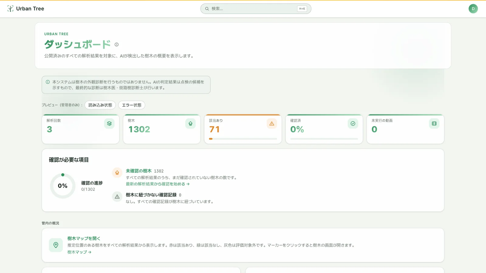 01
01Digitalise the paperwork
Most road and park offices still manage trees and other assets on paper. The dashboard is the first thing we deliver: one platform for every tree and infrastructure asset, its location, its status and its full history, so ledgers and spreadsheets are no longer needed.
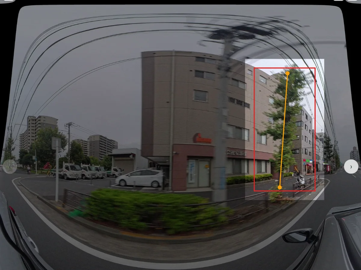 02
02AI screening, fully automatic
A camera mounts on any patrol vehicle with no vehicle modification, and nobody has to press a single button. Data is collected automatically, runs through our in-house, made-in-Japan screening AI, and the results appear on the dashboard so maintenance staff can take action.
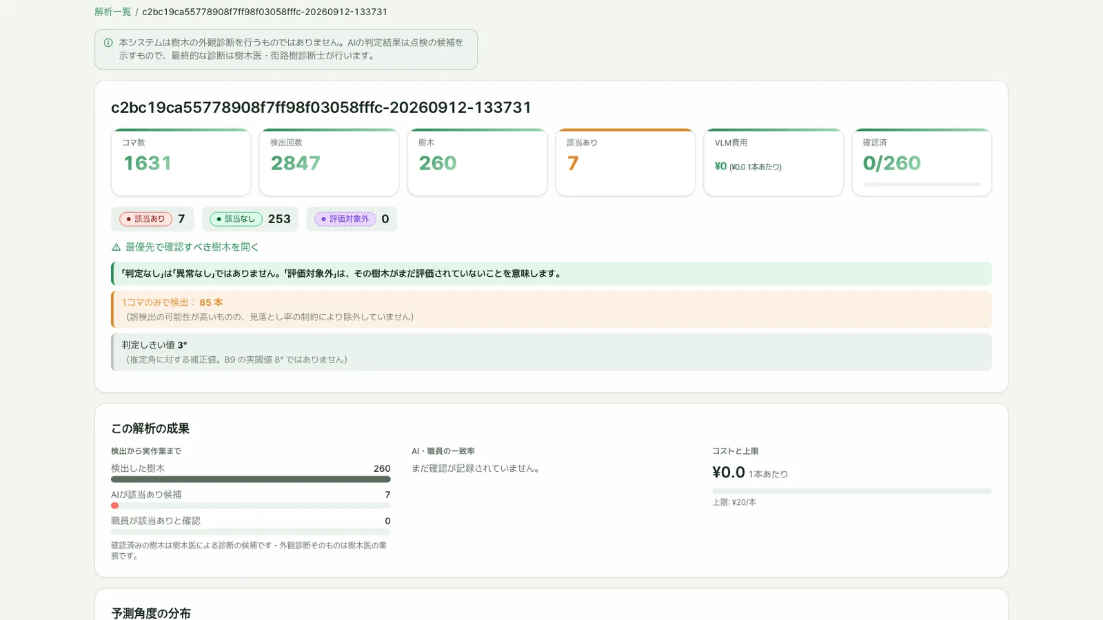 03
03Next-level AI detailed checks
With higher-spec cameras and higher-performance models we go beyond screening: detailed tree health, interference with other infrastructure, and dangers to road and passenger safety. The same approach detects problems with asphalt, rails, lighting and utility poles. We build the bespoke inspection model your assets need.
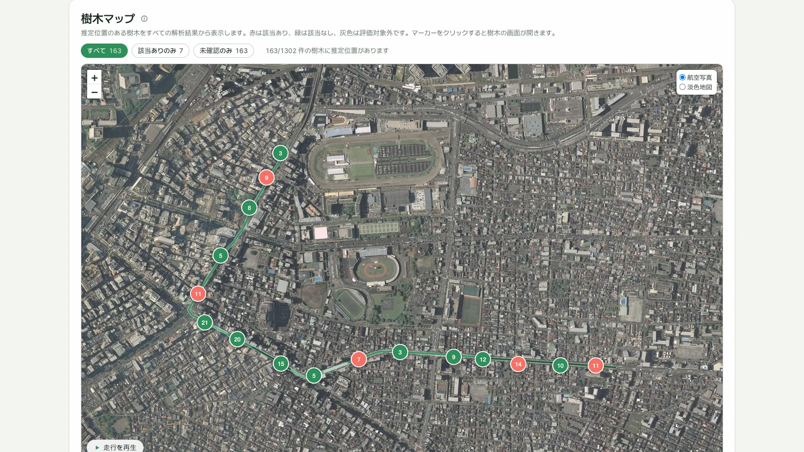 04
04Research beyond the road
The tree model also supports our research and analysis work, contributing to agriculture, plantation management and climate-change studies on the same data foundation.
- We do not collect personal information from the videos.
- All data is stored in Japan.
- The service runs on domestic Japanese servers.
Why teams choose it
Built for the people who manage trees
Fast to start
No survey campaign, no custom hardware. Mount a 360° camera, drive the route you already patrol, upload. First results the same day.
Evidence before score
Every finding keeps its source frame, route, model version and reviewer. Nothing is reduced to an opaque risk number.
Honest about uncertainty
"Not assessable" is a first-class state, never silently merged into "no issue". Low-visibility frames are reported, not dropped.
Scales with your jurisdiction
Tens of thousands of trees per office, repeated every season. Dense tables and filters keep large inventories workable.
Replaces the paper ledger
Verdicts, notes and handover lists live in one place with full history per tree. No re-typing field notes into spreadsheets.
Improves with use
Each staff verdict is a labelled example. Models are retrained on your own reviews, so accuracy rises with every season.
How it works
Four steps from drive to decision
- 01
Capture
A 360° camera records video, GPS and motion data during a normal patrol drive. The files upload from the depot with resumable transfer.
- 02
Analyse
The AI detects and tracks every tree, estimates lean and visible signs per inspection item, and ranks candidates. Quality gates flag footage that cannot be trusted.
- 03
Review
Staff confirm or reject candidates on the map and per-tree screens, with the original frames as evidence. Reviews are recorded with who, what and when.
- 04
Hand over
Confirmed trees go to certified arborists for formal assessment and treatment decisions, with the evidence attached. UrbanTree AI supports that judgment, it never replaces it.
Design principles
What the system deliberately does not do
It does not diagnose
The output is a list of candidates to inspect, never a conclusion. Formal visual assessment remains the work of certified specialists.
It does not guess
Signs that cannot be observed from the footage are returned as "not assessable" with a reason, enforced in the data model rather than only in the interface.
It does not drop anything silently
Tracks without evidence, poor-quality frames and unassessable trees are counted and shown, so completeness can be audited.
It does not invent measurements
Where there is no reliable reference, lean angles and heights are reported as unknown rather than estimated.
Plans
A subscription that fits the size of your area
Pricing is per managed area and billed monthly. Users are unlimited on every plan. Contact us for a quote.
Starter
For a first district or a pilot route
- Up to 1 managed area
- AI analysis and ranked candidates
- Map and per-tree review
- Cloud hosting
- Email support
Office
For a road or park office
- Multiple areas and municipalities
- Devices, dispatch and upload management
- Roles, permissions and audit log
- Seasonal re-analysis with history
- Priority support and onboarding
Enterprise
For prefectures and large operators
- Unlimited areas
- On-premises or private cloud hosting
- Custom inspection items and integrations
- Extension to road surfaces, signs and guardrails
- Dedicated success manager
FAQ
Common questions
A consumer 360° camera (for example an Insta360 X-series) mounted on any patrol vehicle. We recommend models based on your routes and provide the capture checklist.
No. UrbanTree AI screens and prioritises. Confirmed candidates are handed to certified arborists for formal assessment, with the evidence attached.
In a secure cloud region of your choice, or on-premises / private cloud on the Enterprise plan. Video, frames and reviews stay under your organisation's control.
Typically minutes per route once the upload finishes. Results are published to the dashboard with per-tree evidence as soon as they are ready.
The platform is designed for it. Road surfaces, signs and guardrails are on the roadmap and available as custom items on the Enterprise plan.
See UrbanTree AI on your own streets
Send us a route and we will run a pilot analysis so you can review real candidates before subscribing.